Graph points on the coordinate plane to solve real-world and mathematical problems. (5.G.A.1, 5.G.A.2)
5.NF.B
Apply and extend previous understandings of multiplication and division. (5.NF.B.5)
Standards for Mathematical Practice
MP1.
Make sense of problems and persevere in solving them.
MP2.
Reason quantitatively.
MP3.
Construct viable arguments and critique the reasoning of others.
MP4.
Model with mathematics.
MP5.
Use appropriate tools strategically.
MP6.
Attend to precision.
MP7.
Look for and make use of structure.
Map reading is one of the most common uses of a coordinate system in everyday life. In this lesson, students use coordinates to locate and measure distances between locations.
Content in this Lesson
Identifying and describing locations in all four quadrants of a coordinate grid using ordered pairs [E6].
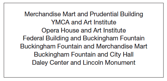
Prepare Chart Paper. Choose 3 or 4 sets of locations on the Chicago Map Master. See Figure 1 for a sample list. Write each set of locations on the top of a sheet of chart paper. Students will record their work for estimating the distance between these locations during the lesson.
Figure 1:Sample list of possible Chicago locations to travel between