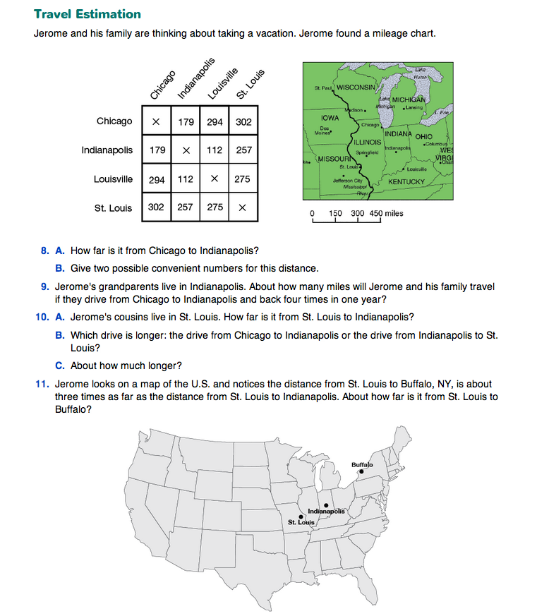
Ask students to turn to the map and mileage chart that accompany Questions 8–16 on the Estimating with Multiplication pages in the Student Guide.
Using a display of the first page of the Travel Estimation section, orient them to reading a map and using a mileage chart by asking questions similar to the following:
- Locate Chicago, Indianapolis, Louisville, and St. Louis on the map.
- Which two cities listed in the chart are about the same distance from Chicago? (Both St. Louis and Louisville are about 300 miles from Chicago.)
- How can you tell from looking at the map? (I found St. Louis and Louisville on the map and they both look like they are about the same distance from Chicago.)
- How can you tell for sure? (I can measure with my ruler in centimeters. They are both about 2 cm.)
- Look at the scale written just below the map. What do you use a scale on a map for? (It tells you how many miles are on the map. You look at the space to see how long it is and then you know how many miles are in that same space on the map.)
- Use your ruler to measure how long the space is between 0 and 150 on this scale. (about 1 centimeter)
- Can you find two cities that are about 150 miles apart? How far apart would they be on the map? (On the map, they would be about 1 cm. Chicago and Madison are about one centimeter apart.)
- So about how far apart are Chicago and Madison according to the map? (about 150 miles)
- Can you find two cities other than Chicago, Louisville, and St. Louis that are about 300 miles apart? (That would be about 2 cm on the map because that is how long the space is from 0 to 300 on the scale; St. Paul and Madison; Indianapolis and Lansing.)
Have students complete Questions 8–12 either in pairs or small groups. Encourage students to use different strategies to solve the problems. Suggest that they record the convenient numbers as they read the mileage chart, instead of trying to store all the numbers in their heads. Ask students to share their strategies in a full class discussion. Discuss what convenient or round numbers they used in their mental calculations.
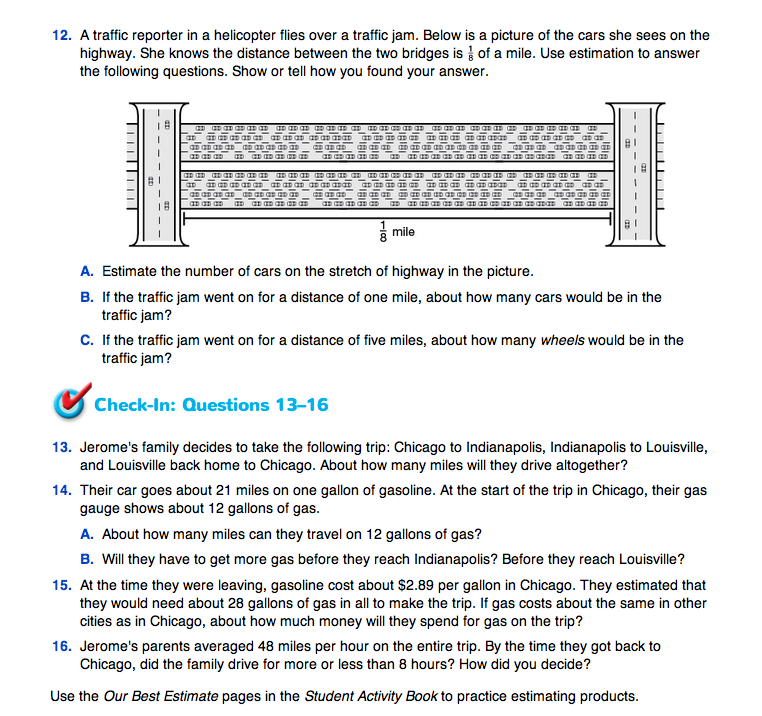
In Question 12, students develop their estimates by analyzing a picture of an 8-lane highway. Emphasize the use of estimation and multiplication rather than exact counting. There are different ways a student can make this estimate. A student could recognize that the number of cars in each lane is approximately the same and therefore, count the cars for only one lane, and then use a convenient number to multiply by the number of lanes to find an answer for Question 12A. Alternatively, a student could partition the highway across 4 lanes and count the number of cars for half or a quarter of the distance shown and then do the necessary multiplication.
Check-In: Questions 13–16 provide a series of estimation problems concerning one child's family road trip. Have students complete these problems individually, writing on a separate sheet of paper.
Assign Questions 8–11 in the Homework section of the Student Guide.

Use Check-In: Questions 13–16 in the Student Guide to assess student progress on the Expectations below:
- E2.
- Multiply numbers that are multiples of 10.
- E6.
- Estimate products.
For students who have difficulty accessing the language in these problems, consider offering the same problems with fewer or simpler words. For example:
- 13.
- About how far are 179 miles, 112 miles, and 294 miles altogether?
- 14.
- A car can go about 21 miles using one gallon of gasoline.
- About how far can the car go with 12 gallons of gasoline?
- Is your estimate more or less than 179 miles? Is it more or less than 294 miles?
- 15.
- Gasoline costs about $2.89 for one gallon. About how much money is needed to buy 28 gallons?
- 16.
- The car travels about 48 miles in one hour. About how many miles would it travel in 8 hours? Is this more or less than your answer to Question 13 above?
The Workshop in Lesson 8 provides targeted practice with estimating products [E6]. The Practice Menu in Lesson 3 provides practice with multiples of 10 [E2].


